Explore the Stirling Range

Explore Stirling Range National Park

The Stirling Range offers limitless exploration experiences, catering for all fitness and engagement levels. Choose from self guided walks or take a spring time guided tour. Breath taking views, incredible mountain features and an emersion into the areas flora and fauna await you! Please heed the important information below the map.
Stirlign Range National Park
1
2
3
4
5
6
7
8
9
10
11
12
13
14
15
16
17
18
19
20
21
22
23
24

Stirling Range Retreat

The perfect base to explore!

Bluff KNoll Cafe

Bluff Knoll Cafe

Please enquire about opening hours as they may vary.

Amelup Roadhouse

Amelup Roadhouse

Nine kilometres north on Chester Pass Road. Deli lines and fuel.

The Lily Dutch Windmill

The Lily Windmill is the only operational flour-producing windmill on mainland Australia.

National Park Fee Collection

Ranger Private Residence

Ridge Walker Registration

Mt James Track

Linking Chester Pass and Bluff Knoll Roads.Forms a 22 kilometre return walk. Commences on Bluff Knoll Road 5.5 km from the junction of Bluff Knoll and Chester Pass Roads.

Toll Peak Picnic Area

Currently closed due to bushfire damage.

Toolbrunup Peak

Altitude: 1052m    Length of track: 4kms return    Hiking time: 3-4 hours    Difficulty : Class 5
A favourite. West from Bluff Knoll, Toolbrunup towers above other mountains. Steep loose rock and scree are encountered on the last quarter of the trail, leading to a summit half the size of a tennis court. Magnificent 360° views. This mountain appeals to hikers wanting a “top of the world experience”.

Moingup Springs

Currently closed due to bushfire damage.

Mt Hassel

Altitude: 847m    Length of track: 3kms return    Hiking time: 2.5 hours    Difficulty : Class 4
This popular hike finishes with a short steep scramble over a dome of rock, forming the summit. Mt Hassel is also well endowed with flowers during spring.
Talyuberlup Peak

Talyuberlup Peak

Altitude: 783m    Length of track: 2.6kms return    Hiking time: 2-3 hours    Difficulty : Class 5

A rock hopper’s paradise. Talyuberlup has interesting chasms, rocky spires and narrow gullies. Some scrambling over rock ledges is required.

Scenic Lookout

Scenic Lookout

A shorter, attractive hike with good views west to Mt Barker

Mt Magog

Mt Magog

Altitude: 856m    Length of track: 7kms return    Hiking time: 3-4 hours    Difficulty : Class 5
The trail, over grown in some places, commences from the white gum/heath picnic area, through a beautiful valley towards the summit. Has pegs as markers for the final kilometre to the summit.

White Gum Flats Picnic Area

Baby Barnett Hill Scenic Lookout

Red Gum Springs

This water source for pioneers is now dry, however a toilet and a picnic area are located here.

Camel Lake Nature Reserve

Mt Trio

Mt Trio

Altitude: 856m    Length of track: 3.5kms return    Hiking time: 3 hours    Difficulty : Class 4

A shorter favourite. The steep trail with some scree begins at the car park with a board walk. Mt Trio has great wild flower displays from mid Aug. to Oct. and, towards the plateau beautiful mountain bells will be discovered during spring. Mt Trio, with three separate peaks linked together by a plateau was originally known as Warrungup

Bluff Knoll

Bluff Knoll

Altitude: 1097m    Length of track: 6kms return    Hiking time: 3-4 hours    Difficulty: Class 4
Listed as one of Australia’s 25 best hikes, Bluff Knoll is the highest peak in south W.A. With 360° views at the summit, it offers ocean glimpses on a clear day. This is a favourite destination for those who enjoy plant diversity & bird watching. Bluff Knoll dominates the view from Stirling Range Retreat. The 8km Bluff Knoll access road is just outside the Retreat’s gate
Stirling Ridge Walk 1

The Stirling Ridge Walk

Maximum Altitude: 1095m    Length of track: 28.8kms circuit from Bluff Knoll to Ellen Peak, returning via North east track to Bluff Knoll Road. Reference map DOLA 1:15,000 “Eastern Stirlings.”    Hiking time: 2-4 days    Difficulty: extreme

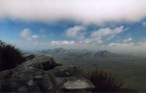
The Stirling Ridge Walk. Ellen Peak from Bluff Knoll Rated one of Australia’s most challenging wilderness hikes.

Stirling Ridge Walk 2

The Stirling Ridge Walk covers the 15.5 km between Bluff Knoll and Ellen Peak. Recommended for experienced, well prepared, fit and agile hikers due to it’s rugged nature, changeable weather conditions and lack of water sources. Hikers can start the walk from either end.

This is the only hike in WA with alpine weather conditions. It involves narrow ledges, very steep ascents and descents and much scrambling over jagged rocks and through sharp bush.

Violent weather change including very strong gusty wind, hail, whiteout, sleet or snow can occur with little notice. It usually involves a two night bivouac, which may be in these conditions, so walkers must be appropriately equipped. The trail is easy to lose, and a compass course may be necessary.

This trail should only be undertaken by those, fit, well prepared and well recorded in the register/log book, and others notified.

Ellen Peak

Ellen Peak

Altitude: 1012m    Length of track: 22kms return    Hiking time: 7-8 hours    Difficulty: Extreme
A 900 metre climb at the eastern end of the Stirling Range Ridge Walk. Apart from the first five kilometres of firebreak, the track is informal and unmarked and easy to lose. A compass traverse may be necessary. Very strong gusty winds and/or white out conditions sometimes occur at short notice. 

Abbey Track

Located 9.96 kms from Formby South Rd and linking Salt River Road with Stirling Range Drive, Abbey track is approximately 10 kms long. Walkers park a second car at the end of the track, and on completion return to pick up their first vehicle.

Click on any number in the menu above to view information about the corresponding location on the map

Important Information

Don't walk alone, company is safety.
Heed all warning signs
Watch your times and returns.
Don't rely on mobile phone coverage.
Follow the signs.
Use sun block even on cloudy days.
Be self honest about your health and fitness.
Stay on the trails and paths.
Be kind to nocturnal animals - use red cellophane at night.
Weather conditions can change rapidly.
Don't pick the wildflowers.
Carry adequate supplies and equipment on long walks - including water and a first aid kit.
Dress appropriately, including good footwear.
Leave nothing but footprints.
SELF HYDRATION - Please carry plenty of water!
Explore the Stirling Range